NATIONAL HURRICANE CENTER

NNuut, we sure hope all you folks get through Irma ok! We pray for the Irma victims and continue to remember the Harvey victims as well. We're only getting periods of rain showers and wind gusts here in southeast NC.

Thanks Kave but 60 MPH Gusts are a walk in the park, but I do have a few bushels of leaves at the bottom of my pool! All is OK at my house but there were others that ended up with a tree on there houses and such, our prayers go to those unlucky ones.
 
Right in the Center of Georgia. Getting 60 mph gusts now, but our electricity is still on!!:laugh:

NNuut, we sure hope all you folks get through Irma ok! We pray for the Irma victims and continue to remember the Harvey victims as well. We're only getting periods of rain showers and wind gusts here in southeast NC.
 
southeast_loop.gif
 
Hope anyone that lives in Florida or have friends and relatives there, that all are safe. Just found out my wife's sister in Tampa has power and are doing OK.
 
It looks like the latest prediction has moved Irma more to the west coast of Florida.

Look out nnuut it's headed your way.


View attachment 42218

It could also head farther west, over water, and/or weaken. If this were such a tradeable scenario, markets would have moved more than they did - since this information was available before the close...remember that typhoon and the nuclear thing a few years back? The market effect (which was less than the economic effect on semiconductor supply); was about 9% and lasted something like a day or two.

I don't think it will make land fall as a category 5, and may not as a 4, or 3. The actual path is very difficult to precisely know 2 days in advance. Miami is not in the cross-hairs currently.
 
Bring it on, I'm No Hurricane Virgin!! At least I'm not sitting 13 miles from the beach again.:cheesy:
 
It looks like the latest prediction has moved Irma more to the west coast of Florida.

Look out nnuut it's headed your way.


irma.jpg
 
The construction business will definitely benefit from these storms, more jobs more profit.
In the Mean time::blink:

b1738159aaa41370c7ed3c3f29219d35--nautical-mile-nautical-art.jpg
 
Latest on Hurricane Irma: Nasty!

Latest data projections and computer models show landfall expected NEAR OR SLIGHTLY NORTH OF MIAMI, then running right up the Atlantic Coast of Florida, into Georgia and the Carolina's.

154730_5day_cone_no_line_and_wind.jpg
 
Hurricanes can be job killers, too!
Jobless claims surge after Hurricane Harvey

Source: The Hill

BY VICKI NEEDHAM - 09/07/17 10:10 AM EDT

Unemployment applications spiked last week to the highest level in more than two years in the wake of Hurricane Harvey's lashing of Texas and Louisiana.

Weekly jobless claims hit 298,000 in the week ending Sept. 2, an increase of 62,000 from the previous week's 236,000, the highest level for initial claims since April 18, 2015, the Labor Department reported on Thursday.

The one-week jump in claims was the largest since an increase of 81,000 in November 2012 after Superstorm Sandy barreled into the Northeast.
Claims jumped 96,000 after Hurricane Katrina hit in September 2005, according to Gus Faucher, PNC chief economist.

With Hurricane Irma bearing down on Florida and the East Coast, claims may experience more surges in the coming weeks.

Read more: Jobless claims surge after Hurricane Harvey | TheHill

Ouch!

That's just the first week- wait until next week, when Harvey's losses sink in, and we get our first chance to see Irma's U.S. job losses......
 
We're scheduled to fly into Savannah next Wednesday (9/13) to go see my son, D-I-L, and granddaughters. Going to be watching Irma closely. We'll most likely be re-scheduling. My son is designated as the first responder to go back into the Arconic factory where he's the Asst. Plant Manager. I doubt we'll get to see him much if they have any damage to the forges. He and the PM were issued chainsaws, safety gear, and A/T trucks so they try to make their way back ASAP as soon as the storm passes.
His insurance covers 80% of any hurricane damage. He's got his 20% in a money market account for such instances.
And my understanding is the taxpayers under FEMA "give" very little that isn't required to be paid back. At least by those who can afford it. That's what my son was told by FEMA officials he spoke with at his plant when they visited.
Yeah, let's pay people that don't work to keep "not working" by providing infinite entitlements. But, penalize those who contribute to the economy by having jobs, and mortgages, and will likely pay back the money loaned in full.
We don't want all those coastal liberals moving to mid-America anyway. They'd never fit in.:sad6:
 
As if Harvey wasn't enough-

"THE HITS JUST KEEP ON COMING"

Now showing THREE additional tropical storms.


[TD="class: hdr"]
TS.gif
Hurricane Irma

[TH="align: left"]Atlantic - Caribbean Sea - Gulf of Mexico[/TH]
[TD="class: reg, align: right"][/TD]

[TD="colspan: 2"]

[TD="align: left"] Tropical Weather Outlook (en Español*) 200 PM EDT Wed Sep 6 2017 [/TD]
[TD="align: right"] Tropical Weather Discussion 208 PM EDT Wed Sep 6 2017 [/TD]
[/TD]

[TD="class: std, align: right"] Satellite | Buoys | Grids | Storm Archive [/TD]

[TD="colspan: 2"]

[TD="class: std, colspan: 8, align: center"]...EXTREMELY DANGEROUS CORE OF CATEGORY 5 HURRICANE IRMA PASSING OVER THE NORTHERMOST VIRGIN ISLANDS...
[/TD]

[TD="class: reg"] 2:00 PM AST Wed Sep 6
Location: 18.5°N 64.7°W
Moving: WNW at 16 mph
Min pressure: 920 mb
Max sustained: 185 mph [/TD]
[TD="class: std, width: 13%"] Public
Advisory
#30A

200 PM AST[/TD]
[TD="class: std, width: 13%"] Aviso
Publico*
#30A

200 PM AST[/TD]
[TD="class: std, width: 13%"] Forecast
Advisory
#30

1500 UTC[/TD]
[TD="class: std, width: 13%"] Forecast
Discussion
#30

1100 AM AST[/TD]
[TD="class: std, width: 13%"] Pronóstico
Discusión*
#28

1100 AM AST[/TD]
[TD="class: std, width: 13%"] Wind Speed
Probabilities
#30

1500 UTC[/TD]
[TD="class: std, width: 13%"][/TD]

[TD="class: std, width: 13%"] NWS Local
Products

1122 AM AST[/TD]
[TD="class: std, colspan: 2"] US Watch/
Warning

153 PM EDT[/TD]

[TD="colspan: 8"]

[TD="class: reg"]
Wind Speed
Probabilities
[/TD]
[TD="class: reg, width: 16%"]
Experimental Arrival
Time of Winds
[/TD]
[TD="class: reg, width: 16%"][/TD]
[TD="class: reg, width: 16%"][/TD]
[TD="class: reg, width: 16%"][/TD]
[TD="class: reg, width: 16%"][/TD]

[TD="class: reg, width: 100%, colspan: 5"][/TD]
[/TD]
[/TD]

[TD="class: hdr"]
TS.gif
Tropical Storm Jose [/TD]
[TD="class: std, align: right"] Satellite | Buoys | Grids | Storm Archive [/TD]

[TD="colspan: 2"]

[TD="class: std, colspan: 8, align: center"]... JOSE IS CLOSE TO HURRICANE STRENGTH ...
[/TD]

[TD="class: reg"] 11:00 AM AST Wed Sep 6
Location: 13.1°N 44.5°W
Moving: WNW at 17 mph
Min pressure: 998 mb
Max sustained: 70 mph [/TD]
[TD="class: std, width: 13%"] Public
Advisory
#5

1100 AM AST[/TD]
[TD="class: std, width: 13%"]Aviso
Publico*
not
available[/TD]
[TD="class: std, width: 13%"] Forecast
Advisory
#5

1500 UTC[/TD]
[TD="class: std, width: 13%"] Forecast
Discussion
#5

1100 AM AST[/TD]
[TD="class: std, width: 13%"]Pronóstico
Discusión*
not
available[/TD]
[TD="class: std, width: 13%"] Wind Speed
Probabilities
#5

1500 UTC[/TD]
[TD="class: std, width: 13%"][/TD]

[TD="colspan: 8"]

[TD="class: reg"]
Wind Speed
Probabilities
[/TD]
[TD="class: reg, width: 16%"]
Experimental Arrival
Time of Winds
[/TD]
[TD="class: reg, width: 16%"][/TD]
[TD="class: reg, width: 16%"][/TD]
[TD="class: reg, width: 16%"][/TD]
[TD="class: reg, width: 16%"][/TD]

[TD="class: reg, width: 100%, colspan: 5"][/TD]
[/TD]
[/TD]

[TD="class: hdr"]
TS.gif
Tropical Storm Katia [/TD]
[TD="class: std, align: right"] Satellite | Buoys | Grids | Storm Archive [/TD]

[TD="colspan: 2"]

[TD="class: std, colspan: 8, align: center"]...KATIA MOVING LITTLE IN THE SOUTHWESTERN GULF OF MEXICO... ...FORECAST TO BECOME A HURRICANE...
[/TD]

[TD="class: reg"] 10:00 AM CDT Wed Sep 6
Location: 21.7°N 95.9°W
Moving: ESE at 5 mph
Min pressure: 1004 mb
Max sustained: 45 mph [/TD]
[TD="class: std, width: 13%"] Public
Advisory
#4

1000 AM CDT[/TD]
[TD="class: std, width: 13%"]Aviso
Publico*
not
available[/TD]
[TD="class: std, width: 13%"] Forecast
Advisory
#4

1500 UTC[/TD]
[TD="class: std, width: 13%"] Forecast
Discussion
#4

1000 AM CDT[/TD]
[TD="class: std, width: 13%"]Pronóstico
Discusión*
not
available[/TD]
[TD="class: std, width: 13%"] Wind Speed
Probabilities
#4

1500 UTC[/TD]
[TD="class: std, width: 13%"][/TD]

[TD="colspan: 8"]

[TD="class: reg"]
Wind Speed
Probabilities
[/TD]
[TD="class: reg, width: 16%"]
Experimental Arrival
Time of Winds
[/TD]
[TD="class: reg, width: 16%"] [/TD]
[TD="class: reg, width: 16%"][/TD]
[TD="class: reg, width: 16%"][/TD]
[TD="class: reg, width: 16%"][/TD]

[TD="class: reg, width: 100%, colspan: 5"][/TD]
[/TD]
[/TD]
[/TD]
*Spanish translations, when available, are courtesy of the NWS San Juan Weather Forecast Office.


Jiminy Crickets!

More information:
http://www.nhc.noaa.gov/?atlc#Irma
 
[TABLE="width: 100%"]
[TR]
[TD]Irma -- now at 180 MPH winds --is the strongest storm ever in our hemisphere since record keeping began.


And it's still at least five days away- and probably 7 days- from hitting Florida.


It's going to be a very, very bad one.

000
WTNT31 KNHC 051742
TCPAT1

BULLETIN
Hurricane Irma Intermediate Advisory Number 26A
NWS National Hurricane Center Miami FL AL112017
200 PM AST Tue Sep 05 2017

...POTENTIALLY CATASTROPHIC CATEGORY 5 HURRICANE IRMA HEADING
TOWARD THE LEEWARD ISLANDS..
.
...PREPARATIONS SHOULD BE NEARING COMPLETION IN THE EASTERNMOST
LEEWARD ISLANDS...


SUMMARY OF 200 PM AST...1800 UTC...INFORMATION
----------------------------------------------
LOCATION...16.9N 59.1W
ABOUT 180 MI...290 KM E OF ANTIGUA
ABOUT 185 MI...295 KM ESE OF BARBUDA
MAXIMUM SUSTAINED WINDS...185 MPH...295 KM/H
PRESENT MOVEMENT...W OR 275 DEGREES AT 14 MPH...22 KM/H
MINIMUM CENTRAL PRESSURE...926 MB...27.34 INCHES


WATCHES AND WARNINGS
--------------------
CHANGES WITH THIS ADVISORY:

None

SUMMARY OF WATCHES AND WARNINGS IN EFFECT:

A Hurricane Warning is in effect for...
* Antigua, Barbuda, Anguilla, Montserrat, St. Kitts, and Nevis
* Saba, St. Eustatius, and Sint Maarten
* Saint Martin and Saint Barthelemy
* British Virgin Islands
* U.S. Virgin Islands
* Puerto Rico, Vieques, and Culebra

A Hurricane Watch is in effect for...
* Guadeloupe
* Dominican Republic from Cabo Engano to the northern border with
Haiti
* Haiti from the northern border with the Dominican Republic to Le
Mole St. Nicholas
* Turks and Caicos Islands
* Southeastern Bahamas

A Tropical Storm Warning is in effect for...
* Guadeloupe
* Dominica

A Tropical Storm Watch is in effect for...
* Dominican Republic from south of Cabo Engao to Isla Saona
* Haiti from south of Le Mole St. Nicholas to Port-Au-Prince

A Hurricane Warning means that hurricane conditions are expected
somewhere within the warning area. A warning is typically issued
36 hours before the anticipated first occurrence of tropical-storm-
force winds, conditions that make outside preparations difficult or
dangerous. In this case, for some of easternmost islands, the
hurricane conditions are expected within the next 12 to 24 hours.
Preparations to protect life and property should be rushed to
completion.

A Tropical Storm Warning means that tropical storm conditions are
expected somewhere within the warning area.

A Tropical Storm Watch means that tropical storm conditions are
possible within the watch area, generally within 48 hours.

Interests elsewhere in the Dominican Republic and Haiti, as
well as Cuba, the central and northwestern Bahamas, and Florida
should monitor the progress of Irma.

For storm information specific to your area in the United
States, including possible inland watches and warnings, please
monitor products issued by your local National Weather Service
forecast office. For storm information specific to your area outside
the United States, please monitor products issued by your national
meteorological service.


DISCUSSION AND 48-HOUR OUTLOOK
------------------------------
At 200 PM AST (1800 UTC), the eye of Hurricane Irma was located near
latitude 16.9 North, longitude 59.1 West. Irma is moving toward the
west near 14 mph (22 km/h), and this general motion is expected to
continue today, followed by a turn toward the west-northwest
tonight. On the forecast track, the extremely dangerous core of Irma
is forecast to move over portions of the northern Leeward Islands
tonight and early Wednesday.

Reports from an Air Force Hurricane Hunter aircraft indicate that
the maximum sustained winds have increased to near 185 mph (295
km/h) with higher gusts. Irma is an extremely dangerous category
5 hurricane on the Saffir-Simpson Hurricane Wind Scale. Some
fluctuations in intensity are likely during the next day or two, but
Irma is forecast to remain a powerful category 4 or 5 hurricane
during the next couple of days.

Hurricane-force winds extend outward up to 60 miles (95 km) from
the center and tropical-storm-force winds extend outward up to 160
miles (260 km).

The latest minimum central pressure reported by reconnaissance
aircraft is 926 mb (27.34 inches).


HAZARDS AFFECTING LAND
----------------------
STORM SURGE: The combination of a life-threatening storm surge and
large breaking waves will raise water levels by as much as 7 to 11
feet above normal tide levels
along the coasts of the extreme
northern Leeward Islands within the hurricane warning area near and
to the north of the center of Irma. Near the coast, the surge will
be accompanied by large and destructive waves.

The combination of a life-threatening storm surge and the tide will
cause normally dry areas near the coast to be flooded by rising
waters moving inland from the shoreline. The water is expected to
reach the following heights above ground if the peak surge occurs at
the time of high tide...

British and U.S. Virgin Islands except St. Croix...7 to 11 ft
Northern coast of Puerto Rico...3 to 5 ft
Southern coast of Puerto Rico and St. Croix...1 to 2 ft

The deepest water will occur along the immediate coast in areas of
onshore winds, where the surge will be accompanied by large and
destructive waves. Surge-related flooding depends on the relative
timing of the surge and the tidal cycle, and can vary greatly over
short distances. For information specific to your area, please see
products issued by your local National Weather Service forecast
office.

WIND: Hurricane conditions are expected within the hurricane
warning area in the Leeward Islands by tonight, with tropical storm
conditions beginning late this afternoon or evening. Tropical storm
conditions are expected within the tropical storm warning area where
hurricane conditions are also possible. Hurricane conditions are
expected to begin within the hurricane warning area in the British
and U.S. Virgin Islands and Puerto Rico on Wednesday, with tropical
storm conditions beginning tonight.

Hurricane and tropical storm conditions are possible within the
watch area in the Dominican Republic, Haiti, the Turks and Caicos,
and the southeastern Bahamas by early Thursday.

RAINFALL: Irma is expected to produce total rain accumulations
of 8 to 12 inches with isolated maximum amounts of 18 inches across
the northern Leeward Islands. Irma is expected to produce total
rain accumulations of 4 to 10 inches with isolated maximum amounts
of 15 inches across northeast Puerto Rico and the British and U.S.
Virgin Islands, and amounts of 2 to 4 inches over southwest Puerto
Rico, the southern Leeward Islands, and Saint Croix. This rainfall
may cause life-threatening flash floods and mudslides.

SURF: Swells generated by Irma will affect the northern Leeward
Islands, Puerto Rico, and the U.S. and British Virgin Islands
during the next several days. These swells are likely to cause
life-threatening surf and rip current conditions. Please consult
products from your local weather office.


NEXT ADVISORY
-------------
Next complete advisory at 500 PM AST.

$$
Forecaster Brown


[/TD]
[/TR]
[/TABLE]
 
Check out the cost of home owners insurance in the southeast when your home is within 20 miles of the ocean.$$$$$$$$anxiety.gif
 
If Irma stays on track the Florida Keys will get hammered. Then Houston might be sweating another hit.

Good luck to all and stay safe.
 
If I had my "druthers"- I'd make it so that people could not build within 100 miles of the ocean, on any surface that is LESS THAN 100 feet above sea level, UNLESS They put, in the bank, on deposit, sufficient funds to rebuild their own house/building, etc.

If you choose to build where hurricanes regularly destroy, then it is up to YOU to rebuild- NOT up to the taxpayers to subsidize you.

well that would solve the global warming problem real quick now wouldn't it? trouble is, where are all those malasians gonna get the money to raise their mud huts up on higher sticks? think people, think.
 
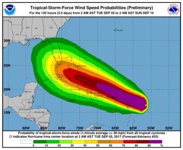
Sadly- Hurricane Harvey is just the beginning of Hurricanes this year- - as now Hurricane IRMA is aiming at Southern Florida.

Here is the 5-day forecast from the National Hurricane Center- with the current computer models of where to expect hurricane force winds over the next 5 days.

Batten down the hatches- here we go again.

irma.jpg


Note:

If I had my "druthers"- I'd make it so that people could not build within 100 miles of the ocean, on any surface that is LESS THAN 100 feet above sea level, UNLESS They put, in the bank, on deposit, sufficient funds to rebuild their own house/building, etc. And I would make flood insurance MANDATORY to build within that zone, and that the flood insurance program pay for itself through premiums, without ANY federal tax dollars in the mix.

If you choose to build where hurricanes regularly destroy, then it is up to YOU to rebuild- NOT up to the taxpayers to subsidize you.

My 2 cents.

These "Once in a million years" storms AREN'T once in a million years.

They are to be expected along the coasts. Hurricanes happen. Flooding happens. If you build in places where the ground is only a few feet above sea level, you should be prepared for the resulting flood.
 
Back
Top